A colouring in, revision or homework sheet on the topic of aerial photography, birds eye view, and maps. Designed for my students in the former Soviet Republic of Georgia, with English as a foreign language who were new to the UK curriculum and style of learning.
Please leave me a review and I will send you any other resource of your choice for free (contact me: office@oceansproject.com). Check out my other resources at my shop: https://www.tes.com/teaching-resources/shop/sarah277
Let me know if you have any resource requests and I will tailor make a resource for you.
A worksheet and video that explorers the history of the Christmas tree in Britain. With links to the Egyptians, Romans, Vikings, Druids, and Celts. What is the connection between the Royal family and Victorians and the Christmas tree?
Video: https://www.youtube.com/watch?v=ouZe2LVRXao
- Why do we put up a Christmas tree?
- When was the first Christmas tree put up in Britain?
- Where did the tradition of the Christmas tree come from?
- What kind of tree is a Christmas tree?
LEARNING OBJECTIVES (KEY STAGE 1-3 History):
1. Pupils should extend and deepen their chronologically secure knowledge and understanding of British, local and world history, so that it provides a well-informed context for wider learning. Pupils should identify significant events, make connections, draw contrasts, and analyse trends within periods and over long arcs of time.
Please leave me a review and I will send you any other resource of your choice for free (contact me: office@oceansproject.com). Check out my other resources at my shop: https://www.tes.com/teaching-resources/shop/sarah277
Let me know if you have any resource requests and I will tailor make a resource for you.
Based on a popular YouTube challenge, students will watch the video (https://www.youtube.com/watch?v=YoNKxLfcKXA), and create their own. This lesson is based on the following learning objectives from the British National Curriculum:
LEARNING OBJECTIVES: ENGLISH KEY STAGES 1-4
1. students should articulate and justify answers, arguments, and opinions.
2. students should give short speeches and presentations, expressing their own ideas, and keeping to the point.
3. students should speak confidently, audibly, and effectively
Please leave me a review and I will send you any other resource of your choice for free (contact me: office@oceansproject.com). Check out my other resources at my shop: https://www.tes.com/teaching-resources/shop/sarah277
Let me know if you have any resource requests and I will tailor make a resource for you.
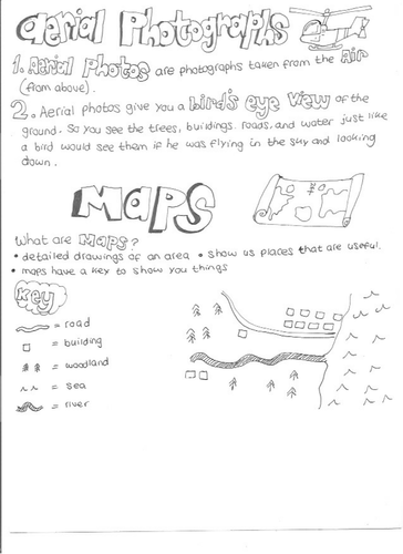
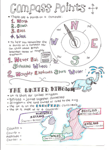
A hand drawn worksheet that I created for my students in the former Soviet Republic of Georgia to help them learn Key Stage 2 Geography with English as a foreign language. Could be given as homework, revision, or used in class.
Please leave me a review and I will send you any other resource of your choice for free (contact me: office@oceansproject.com). Check out my other resources at my shop: https://www.tes.com/teaching-resources/shop/sarah277
Let me know if you have any resource requests and I will tailor make a resource for you.
A collection of KS1 resources on the topic of explorers, exploration, and expeditions. What is an explorer, what does an explorer do, what does an explorer pack, how do they travel, what clothes they wear, comparison of places.
Three Christmas themed bookmarks to colour in.
Please leave me a review and I will send you any other resource of your choice for free (contact me: office@oceansproject.com). Check out my other resources at my shop: https://www.tes.com/teaching-resources/shop/sarah277
Let me know if you have any resource requests and I will tailor make a resource for you.
I created this colouring page for my class as part of our module on the Vikings, journeys, and the British coast. It shows the 'Lerret Boat' which was designed by fishermen specifically for use on Chesil Beach as a result of the steep beaches and local winds.
Other National Curriculum Elements:
- Local knowledge about Portland (geography)
- Vikings
- barrier beach, bar, tombolo
Please leave me a review and I will send you any other resource of your choice for free (contact me: office@oceansproject.com). Check out my other resources at my shop: https://www.tes.com/teaching-resources/shop/sarah277
Let me know if you have any resource requests and I will tailor make a resource for you.
Habitat colouring worksheet to help students get familiar with new vocabulary, with space to add their own plants, insects, or animals.
Follow my educational videos on YouTube: https://www.youtube.com/c/sarahrowssolo
Sign up for a free Skype in the Classroom session as I prepare for my Great British Viking Quest solo row around Great Britain in summer 2017: https://education.microsoft.com/vikingquest
A resource I created for students who want to understand more about the world. A PDF file, that covers:
- THE SCIENTIFIC EXPLANATION of why the sea is salty (references to Isaac Newton, Christopher Wren, King of England, and Edmond Halley's 'continental weathering' theory. We then look at how the question was finally answered in 1979 during an expedition to the black smokers and hydrothermal vents on the Pacific Ocean floor).
- THE FOLKLORE EXPLANATION of why the sea is salty (references to the Vikings, Norse Mythology, Grotti's Song, the Orkney Islands of Scotland and North Atlantic Ocean, and the story of the ants and the friendly giant from the Philippines).
- Suggestions for follow up activities
The file could be broken into sections as a longer topic or workbook, or given as a stand alone project or introduction to a new topic. There are multiple elements that cross over for topics on Vikings, oceans, exploration, biology, geography, slavery, storytelling , folklore, cultural diversity, and as inspiration and scientists who overcame adversity. May be suitable for gifted younger learners, or for secondary school students, STEM clubs, or students with English as a foreign language.
Related Video: https://www.youtube.com/watch?v=OGE0y2t5uao
Please leave me a review and I will send you any other resource of your choice for free (contact me: office@oceansproject.com). Check out my other resources at my shop: https://www.tes.com/teaching-resources/shop/sarah277
Let me know if you have any resource requests and I will tailor make a resource for you.
A geography colouring page to help students learn and remember the inner core, outer core, crust, and mantle of our planet.
You might also want to follow my educational videos on YouTube: https://www.youtube.com/c/sarahrowssolo
Sign up for a free Skype in the Classroom session as I prepare for my Great British Viking Quest solo row around Great Britain in summer 2017: https://education.microsoft.com/vikingquest
A Christmas colouring activity to get your class into the festive spirit. Wassail (a drink made from apples - an English ritual to ask God to bless the harvest and to bring good health in Anglo Saxon times). Perfect for the days when it is too cold to play outside at break. Could also be used as inspiration for writing a story or talking about food and Christmas traditions in different countries.
Follow my educational videos on YouTube: https://www.youtube.com/c/sarahrowssolo
Sign up for a free Skype in the Classroom session as I prepare for my Great British Viking Quest solo row around Great Britain in summer 2017: https://education.microsoft.com/vikingquest
A small collection of photos from my time living and working in the country of Georgia. Bread in Georgia is usually salty and cooked by sticking it to the inside of a round brick oven. It has a classic, flat, shape, with two narrow bits on either end - ideal for holding on to.
Please leave me a review and I will send you any other resource of your choice for free (contact me: office@oceansproject.com). Check out my other resources at my shop: https://www.tes.com/teaching-resources/shop/sarah277
Let me know if you have any resource requests and I will tailor make a resource for you.
A colouring page I created for my students as part of our virtual field trip of Alderney in the British Channel Islands and the German World War Two bunkers.
"German WW2 bunker 'The Odeon' in Alderney. This is about 3 or 4 storeys high and has an anti-aircraft emplacement at the back. Alderney is said to have been the most heavily fortified of the Channel Islands. At one time the allies contemplated landing there as a rehearsal for D-Day". (Wikipedia)
Please leave me a review and I will send you any other resource of your choice for free (contact me: office@oceansproject.com). Check out my other resources at my shop: https://www.tes.com/teaching-resources/shop/sarah277
Let me know if you have any resource requests and I will tailor make a resource for you.
A colouring page that I created for my class when we were learning about World War Two. I drew this after visiting the 'Odeon' concrete bunker on the British Channel Island of Alderney'.
WW2 bunker 'The Odeon' in Alderney. This is about 3 or 4 storeys high and has an anti-aircraft emplacement at the back. Alderney is said to have been the most heavily fortified of the Channel Islands. At one time the allies contemplated landing there as a rehearsal for D-Day". (Wikipedia)
Please leave me a review and I will send you any other resource of your choice for free (contact me: office@oceansproject.com). Check out my other resources at my shop: https://www.tes.com/teaching-resources/shop/sarah277
Let me know if you have any resource requests and I will tailor make a resource for you.
A small collection of photos from my own travels and visits to schools around the world. This is a school in the rural village of Vale in the region of Samtskhe Javakheti, in Georgia. The classroom has no electricity or lighting, and is heated by a log stove that the children look after through the day. In the winter children sit in hats and gloves at their desks. There is no school uniform, and students must buy their own books, paper, and pencils for learning.
Please leave me a review and I will send you any other resource of your choice for free (contact me: office@oceansproject.com). Check out my other resources at my shop: https://www.tes.com/teaching-resources/shop/sarah277
Let me know if you have any resource requests and I will tailor make a resource for you.
A small collection of photos from my own adventures and visits to different types of building and settlement in the city of Tbilisi, in Georgia. The city takes its name from the hot springs, 'tbili' means 'warm' in Georgian - one of the oldest languages in the world.
Please leave me a review and I will send you any other resource of your choice for free (contact me: office@oceansproject.com). Check out my other resources at my shop: https://www.tes.com/teaching-resources/shop/sarah277
Let me know if you have any resource requests and I will tailor make a resource for you.
A small collection of photos from my time living and working in the country of Georgia. Khachapuri is a part of the everyday diet in Georgia, also known as 'Georgian Pizza'. It is like a soft, bready dough, with cheese inside.
Please leave me a review and I will send you any other resource of your choice for free (contact me: office@oceansproject.com). Check out my other resources at my shop: https://www.tes.com/teaching-resources/shop/sarah277
Let me know if you have any resource requests and I will tailor make a resource for you.
A colouring page I created for my students as part of our module on coastal erosion and also used for a lesson on World War Two. Based on the 'hanging rock' on the British Channel Island of Alderney at Longis beach.
"Longis is a settlement in the south-east of Alderney in the Channel Islands, with a beach, island fort, nature reserve, and remains of German, Roman and prehistoric occupation.
Longis nature reserve is the largest nature reserve on the island, with an area of 103 hectares.
Longis Bay Beach is a popular tourist spot. It has an anti-tank wall from the Second World War. This massive, concrete structure curves right around the bay above the high-water mark and was built by the Germans during the Occupation of the early 1940s. There is provision for an anti-tank gun in the middle of its length (long since removed).
For many years it was believed that Alderney's main harbour was located within Longis Bay (as opposed to Braye). A line of boulders was said to point to evidence of a Roman breakwater.
Raz Island, on the Eastern arm of the bay, is connected to the rest of Alderney by a causeway, concreted over by the Germans during the Second World War. It is almost entirely covered by a fort which in recent decades has been used as a house, tea rooms, and as a base for an oyster farm.
Longis has a standing Roman dwelling of significant archaeological importance. Until relatively recently its origin and purpose remained a mystery, the local population referring to it as the 'Nunnery". It has recently been partly excavated. It is pre-dated by find evidence of megalithic or early stone age occupation sites within the Longis Common area.
On the high ground overlooking the western side of the bay stands Essex Castle and the Hanging Rock. A legend says that the reason Hanging Rock overhangs is that the French wanted Alderney so much they tried to tow the island to France by attaching ropes to it, but only succeeded in pulling this large rock out of the ground". (Wikipedia)
Please leave me a review and I will send you any other resource of your choice for free (contact me: office@oceansproject.com). Check out my other resources at my shop: https://www.tes.com/teaching-resources/shop/sarah277
Let me know if you have any resource requests and I will tailor make a resource for you.